
Land Under the Bohemian Crown
The borderland in question is a stretch of the Sudetes running from the Wałbrzych area, through the Owl Mountains, to the Table Mountains and the Kłodzko Land - a stretch where rulers changed for centuries, and the border shifted with them. The origin of the dispute was Kłodzko, which the Piasts and the rulers of Bohemia fought over in the 10th and 11th centuries. It was only settled by the Peace of Kłodzko, concluded on 30 May 1137 between Duke Bolesław III Wrymouth and the Bohemian Soběslav I. From then on, the Kłodzko Land was tied to the Bohemian Crown for centuries.
In 1459, the Bohemian king George of Poděbrady raised the area to the status of the County of Kłodzko. From the 1530s, the Habsburgs gradually took control of it, ruling the region until 1742. Then, after the First Silesian War, under the Peace of Wrocław, the County of Kłodzko passed under Prussian rule along with the rest of Silesia. It was formally abolished as a separate administrative unit only in 1816, when it was incorporated into the Province of Silesia.
Traces of the Bohemian connection survived much longer than the political border itself. The Kłodzko Land remained under the ecclesiastical jurisdiction of the Archdiocese of Prague until 1972, an exception within the territory of present-day Poland. In the tradition of the region's German inhabitants, even after their expulsion after 1945, the notion of the County of Kłodzko functioned as a separate, historical entity, distinct from the rest of Silesia.
How the Border Ran Through the Mountains
The Silesian-Czech border was never a straight line - it ran along mountain ridges, wherever the natural watershed marked out the most convenient frontier. Today's Polish-Czech border on this stretch runs from the Žitava valley, south of Bogatynia, through the Jizera Mountains, along the Jizera valley and the Szklarska Pass, then along the ridge of the Karkonosze (Giant Mountains), and further through successive ranges of the Sudetes towards the Kłodzko Land and the Table Mountains.
The Table Mountains show well how the border divided one geologically coherent massif into two parts. The eastern part, with Szczeliniec Wielki, lies on the Polish side, while the central part, comprising the Broumov Walls and the Adršpach-Teplice Rocks, belongs to the Czech Republic. Today a network of trails links both fragments, but for centuries the same mountain line was also a dividing line: different law, a different ruler, sometimes even a different official language on either side of a single range.
Smuggling and Contacts Across the Centuries
The area around Wałbrzych and the Owl Mountains lay near the former junction of the Silesian-Czech and Prussian-Austrian borders, which - according to local historians - favoured smuggling for centuries. The proximity of two customs systems and two monarchies created a natural opportunity for illegal trade, although the detailed scale of this phenomenon is not well documented in the sources available for this region and needs to be assessed with caution.
Movement across the mountains was not limited to smuggling. The village of Walim, according to local tradition destroyed during the Hussite Wars in the 15th century, owes its origins to settlers from the Rhineland who arrived here to search for silver and gold as early as the beginning of the 14th century - further proof of how open this borderland was to the movement of people in the Middle Ages. Similar migratory and economic threads can be found in the history of the Kłodzko Land, where the Czech parish priest Václav Tomášek built the Skull Chapel in Czermna near Kudowa-Zdrój between 1776 and 1784 - another proof that the state border did not close off the exchange of people and ideas.
The Border Sealed After 1945
After the Second World War, the centuries-long, largely open character of this borderland came to an end. The tightly sealed Polish border with Czechoslovakia, guarded by barbed wire and checkpoints, cut off for many years the movement that had previously favoured smuggling and contacts between residents on both sides.
The final course of the border in its present shape was established in 1958. During this demarcation, Poland transferred 1,205.9 hectares of land to Czechoslovakia, receiving 837.46 hectares in return - a difference of 368.44 hectares arose, referred to in border documents as the "border debt". A Polish-Czech border commission has been settling it since 1992. These were not disputes over whole villages, but corrections to the course of the border line and exchanges of plots along successive sections - yet they show that even decades after the war, the exact course of the border was not entirely settled.
Today's Crossings and Trails to the Other Side
Until 21 December 2007, when both countries joined the Schengen Area, the border in the Table Mountains stretch was crossed by nine crossings - pedestrian, cycling and road: Pasterka-Machovský Kříž, Czermna-Malá Čermná, Radków-Božanov, Ostra Góra-Machovská Lhota, Chełmsko Śląskie-Libná, Pstrążna-Žďárky, and the road crossings Golińsk-Starostín and Kudowa Słone-Náchod. All of them were abolished on that day, together with border controls.
Today the former crossings live on as points along tourist trails. A section of the Main Sudetes Trail named after Mieczysław Orłowicz, marked in red, runs through Kudowa-Zdrój, Błędne Skały (Errant Rocks) and Karłów to Wambierzyce, while yellow and green trails now pass freely through places where documents once had to be shown. Kudowa-Zdrój itself is home to the Interactive Museum of the Kłodzko Land, run as a joint Polish-Czech institution - a symbolic closing of the history of a region that, over the centuries, was at times unified and at times divided.
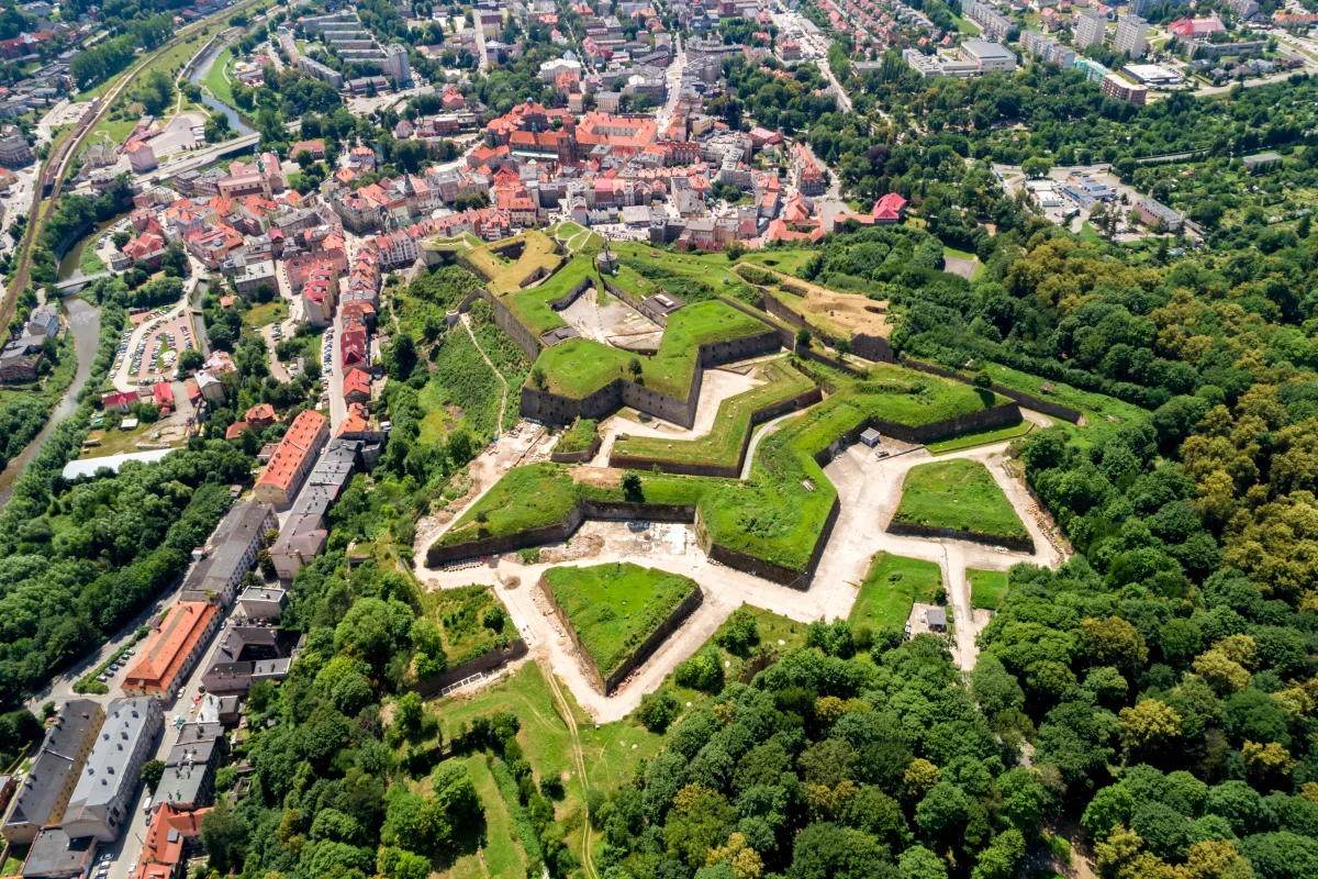
A physical witness to the former border also remains the Kłodzko Fortress, expanded over the centuries precisely because it defended the passage from the Czech side of the mountains into Silesia. Kilometres of its underground counter-mine galleries are a material trace of times when this border was a front line, not just an administrative formality.

Be the first! Add a comment.
You need to log in to add a comment.
Log in